| The Magazine of the CALIFORNIA ACADEMY OF SCIENCES |
|
|
|
Feature California Glaciers
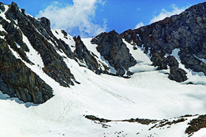
Time is running out for the planet's glaciers. As global temperatures rise, ice blocks on every continent are melting at an alarming pace. Montana's Glacier National Park, for example, will lose its namesakes within 30 years. The Swiss Alps are crumbling without the ice that once held its fractured rock faces together. And at least one scientist has suggested laying a tarp over the famous snows of Kilimanjaro to keep the sun at bay. With trouble looming for glaciers near and far, you might think a fond farewell is in order for California's modest collection of glaciers. Indeed, these holdouts from the last ice age "are living on the edge," says Slawek Tulaczyk, a glaciologist at the University of California, Santa Cruz. The state's southerly latitudes are unhealthily warm for glaciers, and summer melting often outpaces winter snowfall thanks to California's erratic rains. As a result, many of California's glaciers have been reduced to little more than snowfields on the move. Caught in the tug of war between human-induced global warming and the cycle of the ice ages. the prospects of California's glaciers might seem bleak. However, according to new research, these hoary shapers of land and climate are so far holding their own against a warming world. Glaciers are essentially avalanches of ice moving in slow motion. When snow accumulates on a slope year after year, it eventually freezes and begins to slide downhill under its own crushing weight. The movement can be almost imperceptible, on the order of inches a year. In their heyday during past ice ages, California's glaciers included walls of ice hundreds of feet thick, and weighed billions of pounds. The pressure of so much ice ground away whole valleys out of solid rock. Glaciers scoured out the Grand Canyon of the Tuolumne—now home to Hetch Hetchy reservoir—as well as Yosemite Valley. Today, however, the most massive group of glaciers in the state, those blanketing Mount Shasta, amount to less than the volume of ice Alaska's Columbia Glacier loses to the ocean every day. Because California glaciers are so petite, serious glacier scientists have passed them by in favor of trips to Greenland, Antarctica, Alaska, and Iceland. But the specter of global warming and its potentially disastrous effects on California's water supply has finally gained the state's glaciers some respect. It all comes down to water. State reservoirs don't hold enough to keep faucets running through the summer. The steady trickle of melting snow on the mountaintops, which builds to a rushing roar in the foothills, keeps lakes filled and creeks flowing through a dry season that can last six months. "Snowpack is the holy grail of water supply in California," Tulaczyk says. Recent results from climate modelers do not auger well for the state's snowpack. The latest forecast, published in the Proceedings of the National Academy of Sciences in 2004, show temperatures in California warming from 4 to 11 degrees Celsius over the next century, depending on how much more fossil fuels we burn. According to the model, these frozen reservoirs should be well on their way out by then. It predicts the state may lose up to 90 percent of its snowpack over the same period. Those snowpack predictions, however, should be taken with a grain of salt. The models aren't refined enough to consider the powerful effects of topography on weather. In fact, their resolution is so gross that the entire Sierra Nevada barely registers as a hill—implying the snowpack forecasts could be dead wrong. Glaciers offer a way to anchor snowpack prognostication to reality. "Glaciers provide a record of climate change in places where no long-term human record exists," says Ian Howat, a graduate student at the University of California, Santa Cruz. "My ultimate goal is to relate changes in glacier size to variation in climate." Fluctuations in glacier size—and, by extension, historic climate trends—can be inferred from the pile of debris the glacier leaves behind. "Glaciers are like conveyor belts—they move rock from the tops of mountains and deposit it at the base of the glaciers," says Hassan Basagic, now studying Sierra Nevada glaciers. "As the glacier recedes, it leaves behind this large rock pile, a moraine. That's the evidence of its furthest extent." In 2002, Tulaczyk and Howat undertook the first detailed survey of Mount Shasta's glaciers in 50 years. For three consecutive summers, Howat made the trek up to 11,000 feet to photograph the leading edge of the volcano's seven glaciers and gauge their water content. He also installed solar-powered GPS equipment to clock each glacier's downhill advance. Back at the lab, the researchers compared the data against historic maps and photographs as well as local climate and precipitation records. To his amazement, Howat found that Shasta's glaciers are growing. The Whitney Glacier, for example, is galloping forward at the rate of four inches per day. Aerial images indicate Whitney has expanded by about 30 percent in the last 50 years. It is now the only glacier in the world known to be larger than it was in 1890, at the height of a 500-year cold snap known as "The Little Ice Age." The lack of fresh moraines offered further evidence that these glaciers are now larger than they have been for hundreds of years. "We think they're growing because of global warming," says Tulaczyk. The warmer air over the Pacific Ocean can carry more moisture. As they pass over 14,162-foot-high Shasta, the water molecules freeze and descend as snow. This snow gun effect makes Shasta's glaciers more resilient to short-term warming than researchers originally believed. Shasta's proximity to the ocean is key. "Because Shasta is next to this big, moisture-producing ocean, its glaciers are growing. Location is everything," Howat says. Despite a two- to three-degree Celsius rise in local temperatures in recent years, the amount of snow Shasta receives each year currently exceeds summer melt by up to 40 percent. As long as this balance holds, Shasta's glaciers will build up their snow reserves like giant bears fattening before hibernation. But today's heavy snowfall is no guarantee against tomorrow's climate. A few scorching summers in a row, and Shasta's hothouse glaciers could dwindle to nothing within a few decades. "At some point, the effect of more melting due to warmer summers will catch up to the glaciers, and the glaciers will start shrinking again. That may be the situation now in the Sierra," Tulaczyk says.
Today, the Sierra Nevada holds approximately 498 ice features, including perennial ice patches and mountain glaciers. (Counting glaciers requires a unique brand of math. If conditions turn cold, glaciers will merge and fuse into giant ice sheets. If it warms, the areas between glaciers will melt, so you actually get more glaciers before you get none.) The largest of them reside in the bowl-shaped cirques hollowed in the flanks of the highest ridges. The lurch and pull of advancing glacier ice is powerful enough to crumble solid granite. Over eons, these processes will carve a rounded amphitheater with vertical walls. Such alpine glaciers amass most of their snow via avalanches. Howling high-altitude winds redistribute snow across the ridgelines, where it accumulates in bowl-like cirques. There, shade and shelter allow it to linger until it can freeze into glacial ice. "In that sense, the Sierra's glaciers carved out their own niche," Basagic says. A graduate student at Portland State University, Basagic has measured changes in the surface area of seven of the larger glaciers in the Sierra. Dana, Lyell, Kneiss, Maclure, Mendel, Darwin, and Goddard glaciers are located some 300 miles southeast of Shasta, in a line that parallels California's diagonal border with Nevada. He first collected historic maps, glacier reports, and photos dating as far back as the 1890s. He then made the pilgrimage to the mountains to retake the photos from the same vantage point, and to map the extent of the glaciers with GPS for greater accuracy. Once again, the position of the moraines gave him a sense of the glaciers' furthest extent in the 1880s. He found that all seven of the glaciers have retreated 30 to 70 percent over the past 100 years. This is a worst-case comparison; the first archival photos were admittedly snapped at their historic maximum during the little ice age. Yet historical ground and aerial images also show massive amounts of glacier retreat during the drought of the 1930s and 40s. Since then, the rate of glacier surface area shrinkage seems to have leveled off, Basagic says, despite dramatic increases in greenhouse gas levels since the 1970s. "It could be in the Sierra Nevada's case that the glaciers have gotten small enough to where the climate isn't affecting them as much. They've gotten into such little protected areas that it would take a lot of warming to push them into extinction," Basagic says. Lyell Glacier, in Yosemite National Park, illustrates just how important local topography can be. The glacier's protected west arm has diminished 30 percent since 1883 compared to its more exposed east arm, which shrank by 70 percent. For the time being, Sierra glaciers appear far less sensitive to climate change than predicted by the models—excellent news for those of us who raise a glass of California tapwater now and again. Kathleen M. Wong is Managing Editor of California Wild. |