|
California
Academy of Sciences |
 SAN
FRANCISCO BAY: 2K
SAN
FRANCISCO BAY: 2K
SF
BAY FACTS
SF
BAY FACTS
|
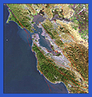 |
The San Francisco Bay and Delta form the largest West Coast's estuary. Together they nourish thousands of species of invertebrates, fish, birds, mammals, insects, amphibians, and plants. The Estuary is the passageway from the waters of the Sacramento and San Joaquin rivers to the Pacific Ocean. The estuary encompasses roughly 1,600 square miles, drains more than 40 percent of the state (60,000 square miles), has about 5 million acre-feet of water at mean tide, and redistributes 80-280 million cubic yards of sediments every year. Twenty thousand years ago, San Francisco Bay did not exist. It was formed by the drowning of a large river valley, which flooded when ocean levels rose because of the melting of the continental ice sheets during their retreat at the end of the last Ice Age. About 10,000 years ago the ocean penetrated the Coast Range through the Golden Gate and began to fill the Bay. The Golden Gate was widened and carved out of hard rock by the powerful tidal currents that still occur each day. Over the last 6,000 years, the deposit of sediments built expanses of mudflats and marshes, creating an amazing and intricate ecosystem. Starting with the Gold Rush, human use and development in the Estuary region have led to degradation of its natural habitats and declines in the numbers of many important native species. Another chronic problem in the Bay has been the introduction of exotic species from distant locations, often in the ballast water of ships. The impact of these over 200 invasive species is being monitored by several projects, including SFBay:2K. |
The entire bay and estuarine system is divided into three main portions (Northern, Central, South) each with distinct hydrodynamics. The largest portion, joined to the open ocean by the Golden Gate, is San Francisco Bay itself. It extends from near Palo Alto to Richmond, where Point San Pablo marks the beginning of San Pablo Bay. The Carquinez Strait (10 km long) connects San Pablo Bay to Suisun Bay, which receives water from the Sacramento and San Joaquin Rivers. The Northern and Central reaches of the Bay have salinity and water circulation patterns controlled by fresh water from the Sacramento and San Joaquin Rivers. Circulation patterns and salinity of the Southern reach are regulated by a combination of ocean and Northern reach waters that enter it from the Central Bay. As a result, salinity levels are higher and more uniform. In a 25 hour period, the Bay typically experiences two unequal high tides and two unequal low tides.
INVERTEBRATE ZOOLOGY & GEOLOGY| ICHTHYOLOGY|EDUCATION | RESEARCH