| The Magazine of the CALIFORNIA ACADEMY OF SCIENCES |
|
|
|
Feature The Geology of Fine Wines
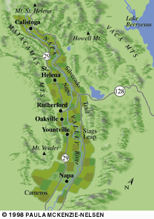
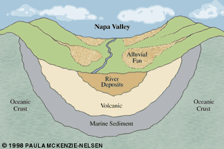
For the past three years, visitors to the Napa Valley have seen rows of milk cartons and grow tubes sprouting throughout the vineyards. They are protecting fragile new grape vines as growers tear out established, decades-old vines and replace them with new plantings. The once-robust grape vines were dying from an aphid-like insect called phylloxerathe pest responsible for wiping out Napa vineyards a century earlier. But the short-term pains of combating the phylloxera plague may have unanticipated long-term payoffs for those who make and enjoy Napa Valley wines. Growers are taking steps to choose new kinds of rootstocks suited to the soils and situations of their vineyards, essentially searching for roots that best match the rocks around them. In the process, they have come to appreciate the nature of Napa Valley, and how its rich, complicated geologic history has created a unique mix of conditions for making wine. What features of the landscape directly contribute, say, to the inky, tannic red wines that come from mountaintop vineyards, or the softer tannins and ripe fruit flavors of the mid-valley benchlands? Few of the millions of visitors who flock to Napa Valley each year to sample from an amazing array of wines aged, blended, and bottled by its more than 250 wineries realize that beneath this abundance and variety lies a geographic grab bag of soils, climates, and landforms. The broad diversity is apparent soon after emerging from the veil of vineyard-enshrouding fog off San Pablo Bay in Carneros and entering from the south the valley's shallow bowl. Lush-looking forests cap the knobby Mayacamas Mountains on the west side, and contrast with the Vaca Range along the east side, marked by craggy, sun-parched summits. From south to north, the valley gets warmer, and the pinot noir and chardonnay grapes common in Carneros gradually give way to plantings of cabernet around Rutherford and zinfandel in Calistoga. From the vantage of the valley's major roadways, Highway 29 and the Silverado Trail, individual vineyards look much the same. They do not readily reveal their subtle yet significant differences. Even on closer inspection, they may not yield secrets specific to their location. Yet grape growers and winemakers, increasingly aware that the land influences the character of wines from a particular place, are seeking patterns that could enhance the product of their mysterious blend of art and science. While many factors combine in still unknown ways to determine a wine's character and quality, four important and interconnected factors appear to be soil, bedrock, climate, and topography. The designation "Napa Valley" adorning wine labels belies the variety within the valley's boundaries. In an area of about 300,000 acres, about one-sixth the size of Bordeaux, Napa Valley contains at least 60 soil types, three out of five recognized grape-growing microclimates, and topography that spans from sea level to 4,500 feet in elevation. This patchwork quilt of soils and microclimates enables a number of grape varietals to be grown successfullythough only about 40,000 acres of Napa Valley are planted or plantableand transformed into world-class wine. More kinds of wine grapes can grow well here than in any area of comparable size. "If anything can be said to characterize this valley, it is the diversity of growing conditions. That's what makes it so exciting," according to sedimentary geologist David Howell of the U.S. Geological Survey. "Sonoma is blessed, too, and has the diversity, but there's no [physical] coherency to it, whereas Napa Valley is a valley." The next time you enjoy a sip or sniff of Carneros chardonnay or Howell Mountain cabernet, take a moment to thank a fortuitous series of geological accidents over the past several million years. The array of rocks shuffled and exposed on the flanks of Napa Valley include oceanic crustal fragments, deep-sea sediments, and volcanic ash. Many of the rocks are, in geologists' jargon, allochthonous, or brought here from elsewhere by plate tectonics. Howell calls these migrants from farflung parts of the Pacific "geologic flotsam and jetsam" carried to California aboard the drifting Pacific plate and scraped onto the coast as that plate slipped under, or subducted, the edge of the continent. Where one crustal plate abuts another, as occurs along the Pacific-North American plate margin in California, friction between the two plates generates heat and causes earthquakes and violent volcanic eruptions. There has been plenty of both in the history of Napa Valley. As recently as four million years ago, the valley did not exist. Then vertical uplift and compression, combined with sideways motion along the San Andreas fault, began to sculpt the present-day topography. Napa Valley today is a bowl-shaped depression, or syncline. The youngest rocks are sandwiched in the middle, flanked by progressively older rocks towards the mountains to the west and east and up their slopes. If you took a slice across the valley, you would expose a series of concentric bands like in a folded layer cake. At the center of the valley floor lie fine-grained clays and sands deposited by the Napa River. To the east and west of these sediments are coarser deposits carried downslope by fast-moving streams as the surrounding mountains rose. Next comes a band of soils made up of weathered volcanic rock. Much older marine sediments comprise the next layer. Finally, chunks of ultramafic (containing minerals high in iron and magnesium) oceanic crust, rarely exposed on land, turn up near the summits of peaks in the Mayacamas and Vacas. Between five and two million years ago, eruptions from several volcanic zones surrounding the present valley blanketed the land in volcanic tuffs, cinders, and ash. Eruptions akin to that of Mount St. Helens in Washington frequently rained down ash that accumulated, over millions of years, in layers thousands of feet thick. One has only to gaze at the giant redwoods strewn about at the Petrified Forest west of Calistoga to appreciate the power of these events. There, a violent blast toppled trees all in the same direction, as happened at Mount St. Helens. Friction from the collision of the North American and Pacific plates provided the heat engine for these eruptions. Today, the subducting plate boundary, and its associated volcanic activity, occurs to the north offshore of the Pacific Northwest.
Relict heat from the molten rocks beneath Napa and Sonoma counties still expresses itself at the surface as active hot springs, notably around Calistoga, and in super-heated steam fields like The Geysers. Located north of Mount St. Helena (the valley's main landmark, but no Mount St. Helens), The Geysers area is the largest geothermal power source in the world and once supplied enough energy to power San Francisco. Wine-weary tourists can sample numerous bottlings of mineral-rich spring waters from the Calistoga region. Rocks formed by lava flows and pyroclastic bursts of volcanism a few million years ago, known as the Sonoma Volcanics, constitute one of the three main bedrock types in Napa Valley. The others are ancient ocean crust and marine sediments. Sonoma Volcanics rock comprises much of Mount St. Helena, which is often mistaken for a volcano itself. Near the town of St. Helena, Glass Mountain, a rich source of jet-black obsidian, also formed from the Pliocene eruptions. Less conspicuous examples of these volcanic rocks can be seen on both sides of the valley, including the weathered white- and cream-colored outcrops upslope from the Silverado Trail south of Calistoga (see sidebar). Misinformed tour guides and books have identified the volcanic outcrops as limestone, a rock commonly found around the great vineyards of France, Italy, and Germany. The structure and stratigraphy of Napa Valley combine to produce a wide array of diverse soil types that range in color from gray to tan to red and can change dramatically in a short distance. Factors that influence soil variability include the parent rock, time, topography, and climate. More than any other factor that contributes to the character of wine from a particular vineyard, soil conditions track an area's geology. At one extreme are the meager and sometimes toxic soils of the oceanic ultramafic rocks, typically marked by sparse vegetation and deep-rooted gray pines. Efforts to grow grapes on such soils usually meet with limited reward. Curiously, despite being a breadbasket state, California chose as its state rock serpentinite, the definitive ultramafic rock that yields the poorest of soils. In contrast, the valley floor harbors deep, well-drained soils rich in minerals and organic matter where grape-growing opportunities abound. High permeability, ample water retention and rich nutrients, however, create their own challenges. Growers curtail vigorous growth, which can impart too much vegetal or grassy taste to a wine, by choosing suitable rootstocks, planting vines closer together, and employing other techniques to coax the varietal character from the fruit. Between these two extremes lie the upland slopes and benches along the hillsides, where thinner, less fertile but mineral-rich and well-drained soils create the natural stress associated with intensely flavored grapes from low-yield, high-quality vineyards. Early viticulturists in the nineteenth century purposefully selected alluvial fans, broad deposits of eroded sediment that form where a stream channel emerges onto flatter land. Many of these estates would become prized vineyards producing sought after reserve bottlings. If the Napa Valley were a flat, featureless plain, like the San Joaquin Valley, its broad spectrum of grape varieties would never have emerged. The combination of tectonics (uplift, faulting, compression) and the varying degree of resistance to weathering of its rocks accounts for the considerable topographic relief and general shape of the valley today. Add the juxtaposition of San Francisco Bay and rugged mountains to the north of Calistoga, and a remarkable range of microclimates gets compressed within Napa Valley. Due in part to influence from the cold California Current that descends southward along the coast from the Gulf of Alaska, the overall climate of the Napa Valley is Mediterranean, with rainy winters and dry summers. But as a sort of box canyon, the valley's topography tends to contain and accentuate climatic differences. Compare the hot, dry lands surrounding Calistoga in the north with the cool moisture from San Pablo Bay in the south. This north-south gradient is the valley's most prominent climate change. Napa Valley contains three of the five recognized grape-growing microclimates, broad bands that cut across the north-to-south-running geologic outcroppings. These climatic regions are described by how much solar heat they receive in a growing season, measured in units called "degree-days." To calculate a degree-day, take the maximum temperature on a day that exceeds 50 ¼F (a 90-degree high would yield a degree-day figure of 40). The sum of these differences for a roughly three-month growing season in Napa Valley will range from about 2,000 to 4,000 growing degree-days (gd-d). Region I in the southern valley, with a cool, foggy, and windy climate dictated by San Pablo Bay, has less than 2,500 gd-d. Region II, in mid-valley from Spring Mountain east to Howell Mountain, has a hotter, more humid climate and between 2,500 to 3,000 gd-d. Region III in the hot northern end of the valley receives about half the rainfall of the mid-valley and has from 3,000 to 3,500 gd-d. Within each of these gross regions there exist local-scale microclimatic exceptions due to exposure and physiography. For example, mountain passes west of Calistoga channel moist fog and marine air from the Russian River Valley to settle in cool pockets in this otherwise parched end of the Napa Valley. Wide daily temperature fluctuations also occur during the three-month growing season, and dramatic differences in temperature and rainfall can be found between hillside vineyards and those on the valley floor. In Europe, winemakers have long acknowledged the role of what the French call terroir, a concept that encompasses the geology and ecology of a vineyard site and how aspects of a specific setting, such as soil, topography, and climate, may influence both the chemistry of the grapes grown there and the flavor of the wines they produce. California grape growers and winemakers have sought to simplify Napa Valley's complex patchwork array of distinctive geologic and climatic growing zones by demarcating regions with similar terroir as subappelations or viticultural areas within the valley. Examples of such American Viticultural Areas (AVAs) include Howell Mountain, Carneros, Mount Veeder, Stags Leap, and the benches of Oakville and Rutherford. These are attempts at acknowledging terroir and identifying for consumers locations best suited to growing particular grape varietals. Yet the process of delineating AVAs can be more politics than science. Boundaries may be drawn along roads, property lines, and other artificial features that cut across areas of similar geology, rather than by using creeks, bedrock, or major topographic features. Some AVAs, however, appear to be grounded in geology. A recent study by Deborah Elliott-Fisk and Ann Noble of the University of California at Davis has shown that the character of Napa Valley soils carries over to the wines. The Davis professors tested cabernets from the Stags Leap viticultural area, on the east side of the valley, comparing flavors and aromas of the wine with the color, texture, pH, and organic content of soil dug from 21 vineyard blocks used in the 1988 vintage. The Stags Leap district contains mostly gravelly soils of volcanic rock that have been deposited by the Napa River. A hard layer a few feet deep constrains grapevine roots and adds stress to vines and fruit. They found qualities that seem to unify cabernets from the wineries of Stags Leap and conclude that unusual soils offer the opportunity to make unusual wines. "Although a number of factors influence wine flavor...," write Elliott-Fisk and Noble, "soil can be an over-riding influence." Such studies suggest that grape growers and winemakers can take advantage of widespread replanting of phylloxera-plagued rootstock from the 1970s and early 80s. They can attempt to match rootstocks and grape varietal clones to specific geologic and climatic conditions. Vineyards are being freshly evaluated, and nurseries are experimenting with new plants. It's too early to say where all the experimentation will lead, but the increased deference paid to terroir, combined with skilled winemakers' traditional blend of art and science, may herald a new era for Napa Valley wines. We may soon wash down the bitter pill of phylloxera with a better-tasting cabernet.
John Livingston is a geologist and owner of Livingston Vineyards in Rutherford, California. He has conducted extensive geologic studies in the West and is a board member of the Napa Valley Vintners Association and Napa Valley Museum. |
Fall 1998
|